The 5-generation Genealogy Project
|
Part 3: Where, exactly, were the Chavez Ravine communities? These has always existed some confusion about where, exactly, the Chavez Ravine communities were located. There is no such confusion about Solano Canyon, since that community was rigorously surveyed and mapped by Alfredo Solano, son of Francisco Solano and Rosa Casanova. Alfred, as he was known, was at various times Assistant County Surveyor and County Surveyor for Los Angeles County, and City Surveyor for the City of Los Angeles. The boundaries of la Loma, Palo Verde, and Bishop, however, known collectively as Chavez Ravine, were less well-defined. On the following map, those boundaries, plus that of Solano Canyon, are outlined. These boundaries admittedly involve a certain amount of intuition, and are not intended to be absolute; rather, they are intended to give the reader a certain sense of the relative locations of the communities. Note that the USGS quadrangle, of which, this map is a portion, shows the locations of the houses that existed at the time. Single black squares represent individual houses; solid black lines indicate houses closely-spaced. 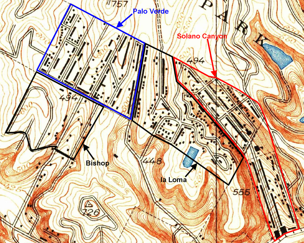 Map source: Portion of the 1928 Los Angeles Quadrangle, US Geological Survey; annotations by the author. The geographic transition from Solano Canyon to la Loma was gradual and quite natural. The houses on both sides of Amador Street are clearly in Solano Canyon; but from there, the loma rose abruptly, and any houses built beyond those on Amador Street were a part of la Loma. Streets in Solano Canyon are Solano Avenue, Casanova Street, Amador Street, Jarvis Street, Bouett Street, and Brooks Avenue to its intersection with Bouett Street, all of which exist today. Streets in la Loma were Brooks Avenue from its intersection with Bouett Street to Effie Street, Phoenix Street, Spruce Street, Agua Pura Drive, Yolo Drive, Pine Street, and Effie Street from Bishop's Road to Yuba Street (which was also its intersection with Figueroa Street). It is likely that all of the houses on Bishop's Road between Effie Street and Park Row were considered a part of Palo Verde. A portion of Brooks Avenue, much of Spruce Street, and a portion of Agua Pura Drive still exist. With a bit of imagination, it is possible to intuit where Phoenix Street, which was never a fully-designated or paved street, existed. Streets in Palo Verde all ran from Effie Street to Park Row, with house numbers ranging from 1700 to about 1875. They were Bishop's Road, Davis Street, Curtis Street, Palo Verde Street (later renamed Paducah Street), Reposa Street, Gabriel Avenue, Malvina Avenue, and Boylston Street. A portion of Bishop's Road exists today in the parking lot of Dodger Stadium, and there still is a short block of Malvina Street alongside the parking lot of the Los Angeles Police Academy, whose address at one time was Boylston Street. The address of the Elysian Park Recreation Center, now the Elysian Park Adaptive Center and where the Los Angeles Theater Academy (LATA) is located today had, at one time, a Bishop's Road address. Streets in Bishop ran southwest from Effie Street, with house numbers below 1700. They were Davis Street, Paducah Street, Shoreland Drive, Home Place, Boylston Street, and Garibaldi Street. There is a short bit of Boylston Street that exists today; it is high on a loma, with a spectacular view of the fireworks displays that take place on certain Friday evenings following baseball games at Dodger Stadium. Before the evictions, the view would have been of the homes of their neighbors who lived with them in Bishop. The following map is a 1948 aerial photograph, in which individual houses may be seen — hundreds of them, in all the communities. This photograph was taken just two years before the evictions began. The four communities are outlined as before, except that la Loma and Bishop are outlined in yellow for clarity. 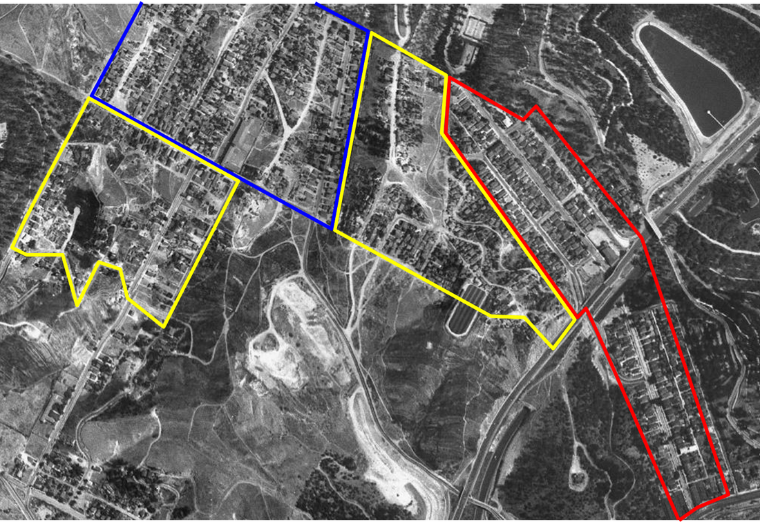 Portion of a 1948 aerial map Finally, take a look at nearly the same aerial photograph, this one taken in 1952 — two years after the evictions began. There's not much that may be said about the destruction that had taken place in just two years, so see for yourself ... 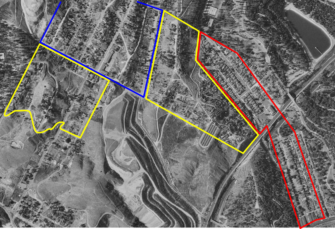 Portion of a 1952 aerial map While a few scattered houses remain in Chavez Ravine, mostly in Palo Verde, the end had already been determined and was clear. Thus, less than seven years after this heart-rending photograph was taken, out of a well-developed, vigorous, and tightly-knit community of about 1,400 families, all of the houses in la Loma, Palo Verde, and Bishop — nearly 1,100 in number — had been leveled. Solano Canyon, which will celebrate its 150th anniversary in 2016, was the lone survivor.
|
About the AuthorLawrence
Bouett is a retired research scientist and registered professional
engineer who now conducts historical and genealogical research
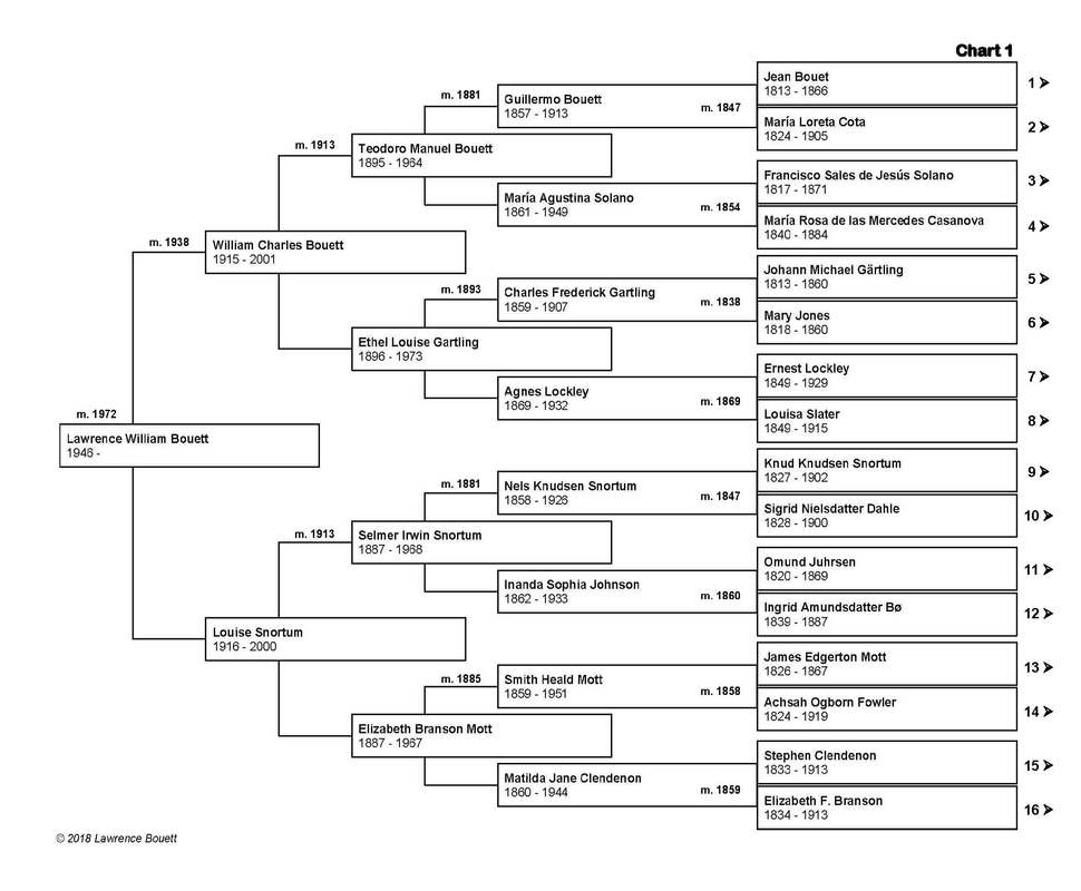
full-time. A ninth-generation Californian, he is particularly interested in the displacement of the nearly 1,100 families that lived in the Chavez Ravine communities of la Loma, Palo Verde, and Bishop to make way, ultimately, for the construction of Dodger Stadium. His ancestors arrived in California with Portolá in 1769 and came to Los Angeles with the founders on September 4, 1781. 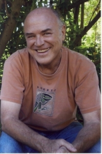
CategoriesArchives
January 2018
|
 RSS Feed