The 5-generation Genealogy Project
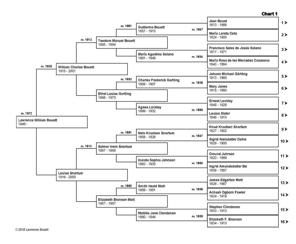
What is the 5-generation Genealogy Project? By the time the residents of the three Mexican and Mexican-American neighborhoods of Palo Verde, Bishop, and La Loma were evicted during the 1950s, more than 6,000 people had been documented as their having lived in the neighborhoods of the so-called Chavez Ravine in the Stone Quarry Hills. Every one of those residents has a genealogical history, much of which goes back to México in the 18th, 17th, and, in some cases, the 16th and even the 15th Centuries. A complete five-generation 'family tree' chart contains the names of 30 of the immediate ancestors of any given person (see the author's chart at the top of this post for an example of a 'full' 5-generation chart), for a total of 31 people per chart. In chart form, a 5-generation family tree typically extends back in time about 200 years, on average. Some of you may already know the names of the 30 immediate ancestors of yours; but some of you may not and you may wish to know more. That is where the role of a competent genealogist come in. Using expert knowledge acquired through long experience doing research on family genealogies, an experienced genealogist is often able to locate documents that establish the identities of people in one's chart. The 5-generation Genealogy Project is a new and ongoing project of this blog that allows people who are interested in documenting their genealogies to acquire that information at a reasonable cost and to obtain copies of the birth, marriage, death, and other records of their ancestors that they might not already have. The 5-generation Genealogy Project is focused entirely on the genealogies of the people who lived in Palo Verde, Bishop, and La Loma between 1909 and 1950 — in other words, the residents of Chavez Ravine. Using publicly-available records, the 5-generation Genealogy Project will attempt to fill in and document the names in any 5-generation family tree chart, beginning with a documented Chavez Ravine resident, even if that person was not actually evicted during the 1950s. Please be aware that, unfortunately, it is not always possible to fill in every blank on every chart. What does it cost to join the project? A quick online check of the cost of genealogy research shows that it can cost anywhere between $20–$100 an hour or more to hire a genealogist. The average is probably somewhere between $35–$60 an hour. The cost of becoming a member of the ChavezRavine.org 5-generation Genealogy Project is $149. This is a flat fee that represents the total cost of your participation in the project. There are no additional costs or charges involved in participating as a member of the project. What will I get for my money? This is the right question to ask. Beginning with the information you initially provide, the project will conduct the research necessary to document what you already know and will attempt to extend it for at least five generations. I say "... at least five generations ..." because in one recent case, it was possible to document not just 5, but 13 generations — into the late 1500s! You will eventually receive all relevant charts — which may extend for more than five generations onto additional charts (see the previous comment) — along with digital images of all census records, marriage records or certificates, and any other records that were located during the research to document your ancestors. Other records may include immigration records, draft registrations, naturalization records, and anything else that was located. You will also receive an ahnentafel, which is a record of every family member that was located during the research process, including siblings of your ancestors (your cousins). The word 'ahnentafel' literally means 'ancestor table', and has been in use since it was first 'invented' in 1590. It is the basis of the 5-generation chart. [Michaël Eytzinger, Thesaurus principum hac aetate in Europa viventium, Cologne, 1590.] 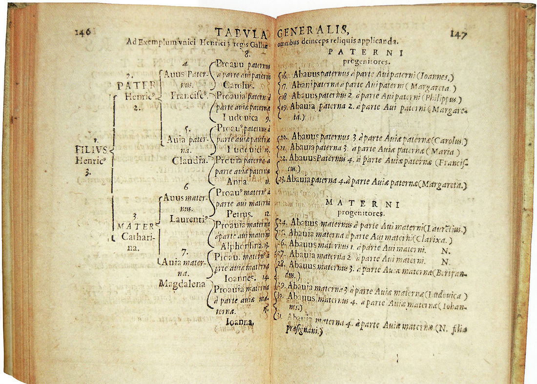 Michaël Eytzinger's original ahnentafel, 1590 What experience does the project have? That's another great question. The author has been conducting genealogical research for more than 45 years. In terms of Mexican research, he has viewed, documented, and translated more than 20,000 Mexican records, dating from 1588 through the present. Nearly all Mexican records, both religious and civil, have been microfilmed and are available — the trick is in knowing where, and how, to look, and how to interpret the information that is contained in the records. How do I apply for the project? A participation form has been developed for you to apply to be a part of the ChavezRavine.org 5-generation Genealogy Project. If you want to apply, simply click on this link. That will bring up an online application that you may fill out and submit on your computer. Provide all the information you can, based on what you already know. Some fields on the form are required; the form will prompt you if information is required. When you have provided all the information you can on the form, simply click the "SUBMIT" button at the bottom of the form, and it will be emailed to the 5-generation Genealogy Project. The next step is to pay the $149 fee. There are many ways to submit online payments, and in fact, you may already be using one of these convenient online methods. Payment may be made using Zelle, Square Cash, Venmo, or any other online digital payment system. Digital online payments typically require the recipient's email address and contact telephone number. Direct your payment to the email address lbouett@gmail.com and use contact telephone number 925-357-5294. Alternately, you may mail a check directly to the author at the following address: Lawrence Bouett 640 Moraga Rd Apt 211 Moraga, CA 94556 How long will the research take? That's a good question, and one for which, unfortunately, there is no good answer.. The truth is that is will take as long as it takes, although the time it does take — whatever that is — is completely covered by your one-time project fee of $149. Once your application has been received, there will undoubtedly be some — perhaps many — questions that the author will want to ask to clarify the family or the individuals you want to document. Since you must provide an email address on the application form, you will be contacted by email directly with any questions.. Of course, you may always contact the author at any time using this email address. The 5-generation Genealogy Project has become the author's life work; I look forward to working on your project. I believe it is critically important that we not forget the more than 6,000 residents of Chavez Ravine: those who lived in the neighborhoods of Palo Verde, Bishop, and La Loma. I further believe that we honor those residents by documenting their (and, by extension, your) ancestors. Want to know more about the project? If you have questions about the 5-generation Genealogy Project, contact the author here: Don't give away your family's heritage and history The subtitle of this blog is really a warning: Don't Give Away Your Family's Heritage and History. The Chavez Ravine neighborhoods of Palo Verde, Bishop, and La Loma were physically destroyed during the 1950s.. In case there is any question about what it looked like in the Stone Quarry Hills after the eviction notices were handed out, look at these Before and After aerial photographs. First, this is the village in 1948 — two years BEFORE the evictions and condemnations began. 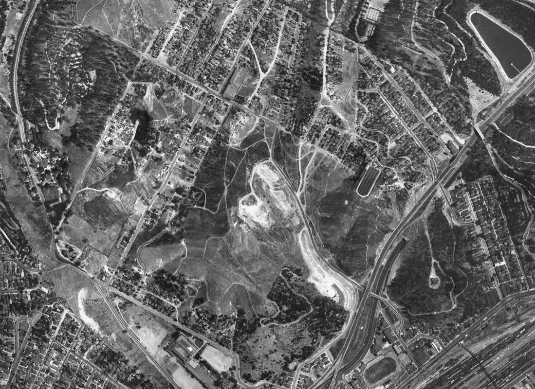 Now compare the view above with what the same area looked like in 1952 — just four years later and two years AFTER evictions began. 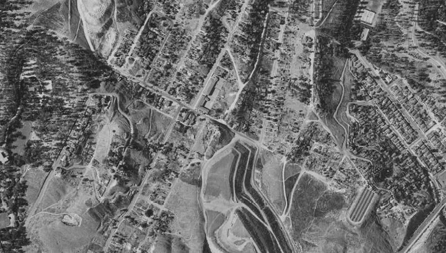 What remained after the evictions Following the evictions, the houses were gone — either sold and moved, destroyed, or used as practice for the Los Angeles Fire Department — and the land was bare. The fact is that all that remained of Palo Verde, Bishop, and La Loma was what residents took with them, including household goods, furniture, clothing, and — importantly — family documents and photographs. It is those precious family documents and photographs that is the focus of this blog. There are some who have tried to take your family's history — your documents and photographs — from you Your precious documents and photographs belong to you. It is important that you think very carefully before you turn over possession of your unique family history to another person. It is one thing to allow your family history to be copied and returned to you; but it is another thing altogether to give it to someone who will keep it for their own purposes and not return it to you. If you do give it away, it may be lost forever to you and your family. There have been several attempts to acquire family documents and photographs from the survivors of the evictions of Chavez Ravine and their descendants. One such attempt even requires families to sign a Deed of Gift, which would seem to give possession of your property to individuals, to be used however that person wishes, and never returned to you. It is the position of this blog that requiring you to sign away your right of possession to your own family history is both unethical and immoral. But there is something you can do ... Sign a Document of Rescission to demand the return of your property and your family's history A Document of Rescission sounds like a fancy legal term. It is, in fact, a legal term, but it is not fancy and it may be a way that you can get your property returned to you. There are eight ways to void any Deed of Gift you may have signed; but three of them are very clear and may apply to you:
If any of these three things is true, then you are completely within your rights, legally-speaking, to demand that the Deed of Gift be voided and to regain possession of your property. You can do this by signing a Document of Rescission. The first of these three reasons to justify voiding a Deed of Gift is very straightforward: you may not have understood clearly what you were signing. It's just that simple The second one is also straightforward: say the person or persons promised that there would be a public meeting to explain their project and that meeting never took place. The third is a little more complicated, but let's say that is has become clear that it would be better (in the public interest) if you, the original owner of your property, were allowed to keep what rightfully belongs to you. Since the village in the Stone Quarry Hills, consisting of the neighborhoods of Palo Verde, Bishop, and La Loma, was destroyed, the only record of its existence may be your family's documents and photographs, and to give them all to one person would effectively rob you, your families, and your neighbors of that heritage. Think about what you and your family will lose if you give your heritage and your family's history away Information on Rescission of a Contract from the State of California may be found here. A link to a Document of Rescission may be found by clicking on the Buried Under The Blue. image, below.  The name 'Chavez Ravine' is a misnomer here was in Los Angeles by 1950 a thriving, vibrant, predominantly Mexican and Mexican-American village of more than 5,000 people living in the Stone Quarry Hills about a mile to the Northeast of downtown Los Angeles, a village that comprised the three neighborhoods of Palo Verde, La Loma, and Bishop. It is well-known that the village was condemned and destroyed during the following decade so that a Federal public housing project known as Elysian Park Heights could be built. Elysian Park Heights, for a variety of reasons, was never built, and once ownership of the land had reverted to the City of Los Angeles by mid-decade, it was subsequently sold to Walter O’Malley, who brought his Brooklyn Dodgers baseball team to Los Angeles in 1958. O’Malley used a portion of the land he received from the City to build Dodger Stadium, which opened on April 10th, 1962 as the home of the now-Los Angeles Dodgers. The village that once existed in the Stone Quarry Hills has been referred to for decades as ‘Chavez Ravine’; that term is firmly a part of the lexicon of the area, and it is used today to refer, not only to the village that was destroyed, but also to Dodger Stadium itself. However, use of the term ‘Chavez Ravine’ to describe the Mexican and Mexican-American village in the Stone Quarry Hills that was made up of the three neighborhoods of Palo Verde, La Loma, and Bishop is a misnomer; in fact, its use as a name for the village is historically inaccurate in every way and it improperly describes the area. Urban legends abound, and in this case, the name ‘Chavez Ravine’ actually comes from the nearby geographical feature of the same name. The Stone Quarry Hills is the elevation on which sits Los Angeles’ Elysian Park. The land was uplifted millions of years ago in geologic time, and as the land rose, rivers cut the land, producing five ravines that are known in modern times, from Northwest to Southeast, as Chavez Ravine, Sulphur Ravine, Cemetery Ravine, Solano Ravine, and Reservoir Ravine. Chavez Ravine was named for Julián and Mariano Cháves, brothers from New Mexico Territory who were active in Los Angeles during the mid-19th Century. The ravine was so-named because there was a burro trail that led up the ravine, crested the summit of the Stone Quarry Hills, descended through a narrow defile, and debouched onto the flat land to the Northeast of the hills by the Los Angeles River. This land was owned, in 1856, by Julián Cháves, his brother, Mariano, and Juan Bouet. Originally referred to as Frogtown, it is known today as Elysian Valley. Complicating the urban legend, however, is the fact that neither Julián Cháves nor his brother, Mariano, had any connection whatsoever to the three neighborhoods of Palo Verde, La Loma, and Bishop, nor did they, at any time, own any of the land in the village that eventually was destroyed or to the land where Dodger Stadium sits today. Chavez Ravine, the westernmost of the five ravines in the Stone Quarry Hills, has no direct geographic connection to any of the neighborhoods.[1] Of the three neighborhoods that comprised the village, La Loma existed entirely on the loma between Solano and Cemetery Ravines. La Loma got its name because of the loma on which most of the neighborhood was built, and it was contiguous with the upper portion of the present-day community of Solano Canyon on its southeast edge and with Bishop on its northwest edge. There are first-generation survivors of the evictions of the 1950s who describe walking down the loma from La Loma to visit friends on Amador Street or Solano Avenue ‘in Solano’, or who talk about how, as children, they left La Loma to walk ‘through Solano’ to attend school at the Solano Avenue School.[2] 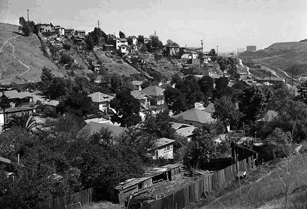 Bishop, with only 80 houses along the two blocks of Bishops Road between Effie Street and Park Row in 1940 — the 1700 and 1800 blocks — was the smallest of the three neighborhoods, both in area and in population, and its only street was Bishops Road. Sometimes improperly referred to as its being located in Bishops Canyon, a geographical feature that never existed, Bishop was actually located entirely within Cemetery Ravine. Although the sides of several of the ravines in the Stone Quarry Hills, including Chavez Ravine, were steep, none could properly be described as a canyon. As the land rose again to the Northwest from Bishops Road onto the loma that was between Cemetery and Sulphur Ravines, the houses that were built there became part of the Palo Verde neighborhood, beginning with the houses along Davis Street. This largest of the three neighborhoods continued for six blocks along Effie Street, all the way from Davis Street to Boylston Street; it existed on both sides of Effie Street. Where did the name 'Chavez Ravine' come from? There has been extensive, legitimate use of the term ‘Chavez Ravine’ over time. Maps as early as 1856 labeled the westernmost of the five ravines in the Stone Quarry Hills ‘Chavez Ravine’. This was due to the fact that the aforementioned burro trail that led up that particular ravine provided access to the 82-acre tract that was acquired in 1847 by Julián Cháves. Cháves’ property was located on the flat land by the Los Angeles river that was later called Frogtown and which is known today as Elysian Valley; in 1856, Cháves’ land was adjacent to the 33-acre parcel of his brother Mariano, which in turn was adjacent to the approximately-150-acre parcel of Juan Bouet. Equally as important as the access that the trail up Chavez Ravine provided to the Cháves and Bouet properties on the flat land near the Los Angeles River in Frogtown was the fact that the same trail also provided access to the San Fernando Valley and to the land to the North of Los Angeles, such as Rancho Los Féliz and Misión San Fernando Rey de España. The term ‘Chavez Ravine’ had also been used for decades prior to the 1950s to refer to locations and events in the actual Chavez Ravine, such as the locations of the several Pest Houses of the mid- to late 19th-Century, the Barlow Respiratory Hospital, which was built in 1903 along Chavez Ravine Road, several brickyards, and the Naval Reserve Armory of the 1940s, which, like the Barlow Hospital, was also located along Chavez Ravine Road. All of these places were in Chavez Ravine itself or along Chavez Ravine Road. The three destroyed neighborhoods of Palo Verde, La Loma, and Bishop were nowhere near the geographical feature called Chavez Ravine. Neither Julián Cháves nor his brother, Mariano, ever owned land in Chavez Ravine itself or had anything to do with the land that became the three neighborhoods that were eventually destroyed. Dodger Stadium, which has also referred to as Chavez Ravine by some, was built primarily in Sulphur Ravine, on the loma between Sulphur and Cemetery Ravines, and against Mt. Lookout. So how, then, did that entire area of more than 340 acres that was condemned during the 1950s come to be called ‘Chavez Ravine’, since the term is so clearly used inappropriately today to describe anything that was ever built there? The answer can probably be attributed to Frank Wilkinson, Special Assistant to the Executive Director of the Housing Authority of the City of Los Angeles (HACLA) under HACLA Executive Director Harold L. Holtzendorf, in 1950. As Special Assistant to the Executive Director, Frank Wilkinson was powerful, his authority was great, his responsibilities were as broad as he and Executive Director Holtzendorf cared to make them, and Wilkinson was instrumental — although not the primary driver — in the process that led to the eviction of the residents of the so-called ‘Chavez Ravine’ communities and the ultimate destruction of their homes. The first documented use of the term ‘Chavez Ravine’ to refer to that part of Los Angeles that included the neighborhoods of Palo Verde, La Loma, and Bishop occurred on 24 July 1950 in the form of a certificate, prepared by Wilkinson himself and issued under the signature of Sidney Green, Management Supervisor of the Housing Authority (HACLA). By Wilkinson’s own admission, the certificate, which he says he wrote, was distributed personally by him to every home in all three of the neighborhoods. The assertion that it was Wilkinson who wrote and distributed the certificates is documented in the film, Chávez Ravine — A Los Angeles Story, in which Wilkinson, who was interviewed on-camera for the film, says that it was he who personally wrote the July 1950 certificate and delivered it to every household. That certificate was effectively a death warrant for the way of life in the Mexican and Mexican-American village that contained more than 1,100 homes and 5,000 people, although that outcome had very likely already been determined by HACLA.
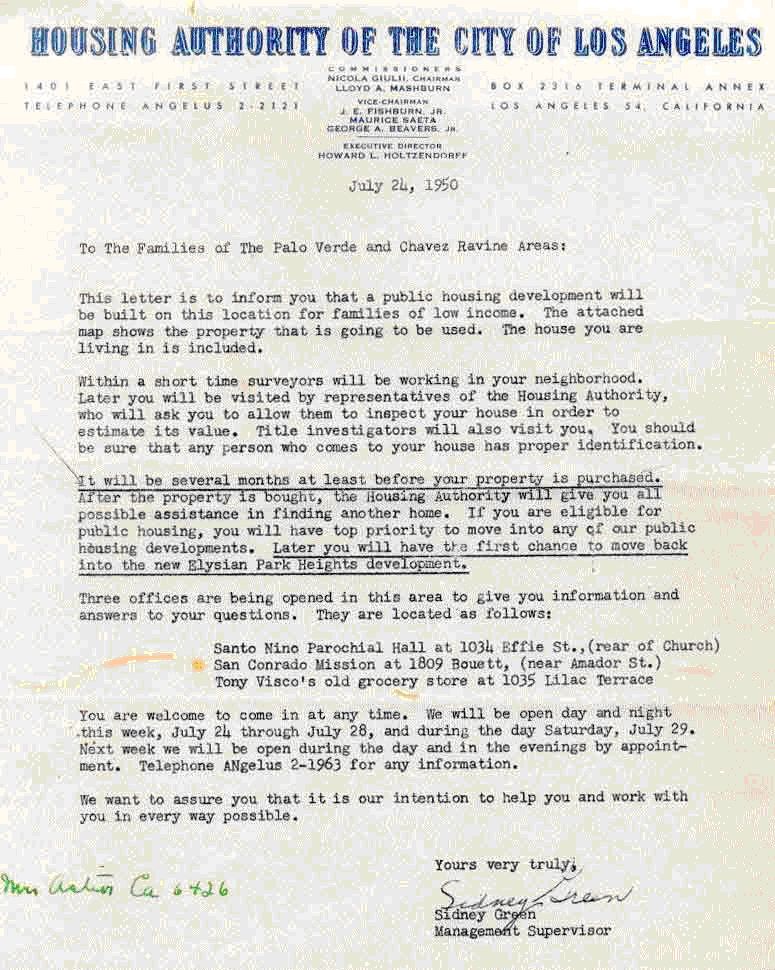 Just how, why, and under what circumstances Frank Wilkinson used the term ‘Chavez Ravine’ to describe a portion of the area that was ultimately condemned and destroyed, is not known. The term was also used by Wilkinson’s boss at HACLA, Harold Holtzendorf, although Holtzendorf appeared to use the term to refer to the entire area, while Wilkinson also used the term ‘Palo Verde’ in the same context. Once used, however, the term seemed to stick, and it was used widely and repeated often, especially by the Los Angeles Times in its hundreds of reports of the dozens of public meetings that were held by the Housing Authority about the public housing project that was known as the Elysian Park Heights public housing development. Once the minority Mexican and Mexican-American residents of the communities of Palo Verde, La Loma, and Bishop were evicted from their homes, their properties condemned, and their homes destroyed; once the public housing project known as Elysian Park Heights was abandoned, largely due to public, lobbying, and political pressures; once ownership of the land had reverted to the City of Los Angeles with an assist in Congress from California United States Senators Richard M. Nixon and William F. Knowland; and once Walter O’Malley had brought his Brooklyn Dodgers baseball organization to Los Angeles and built a stadium on the land that had once been the home to more than 5,000 people, most of whom were Mexicans and Mexican-Americans; at that point, Vin Scully and Jerry Doggett, the ‘voices of the Los Angeles Dodgers’, began to use the term to describe the baseball stadium itself, which is a misnomer if ever there was one. One can perhaps understand, however, their reluctance to refer to the stadium as ‘Sulphur Ravine’. By that point, then, the term ‘Chavez Ravine’ to refer to the area that was more properly referred to as ‘Palo Verde’ had become so firmly implanted in the minds of most Angelinos that it would have been virtually impossible to convince anyone that the more than 5,000 residents of the destroyed neighborhoods of Palo Verde, La Loma, and Bishop never themselves referred to the location of their homes as ‘Chavez Ravine’— not that anyone tried, of course. There are many of those who were evicted who are alive today, although their number is dwindling over time, and not one of them has ever come forward to claim that they called the area where their homes were once located by the name ‘Chavez Ravine’, even though many of them may use the term casually today. Some of the eviction survivors are friends and family members of the Santillán family; they have formed a loose but loyal organization of evictees who have met annually during the Summer for nearly four decades and who call themselves Los Desterrados. Others have formed additional informal family or neighborhood groups. Frank Wilkinson ultimately expressed his regret at that he had accomplished.
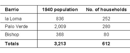
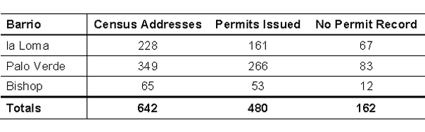
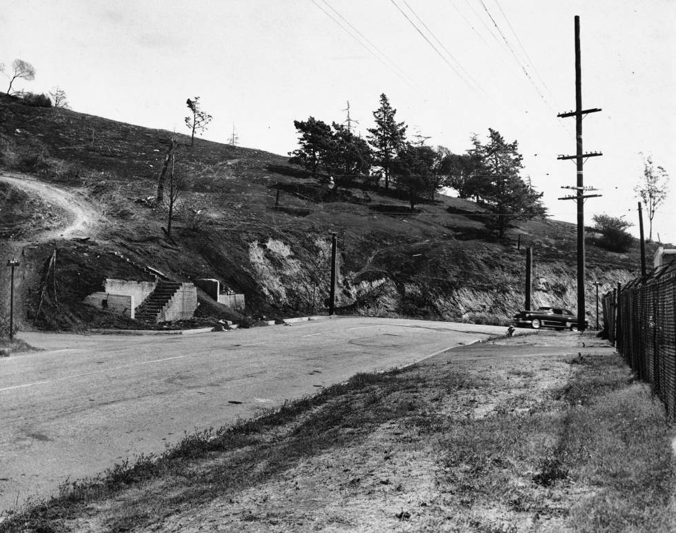
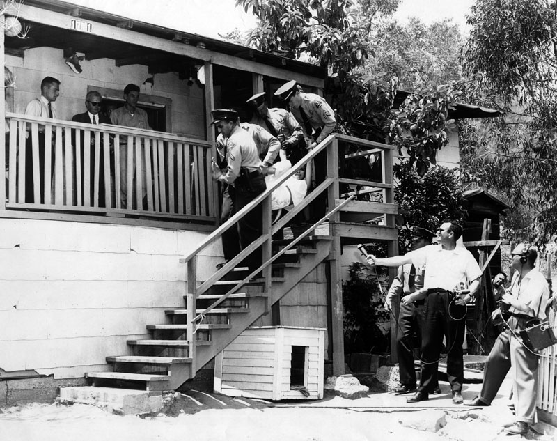
While the destruction of more than 1,100 homes in the three neighborhoods and the eviction and scattering of its residents from their homes may represent the tragedy of Frank Wilkinson’s life (which seems doubtful, given subsequent events), it is also fair to say that those same events represent the singular tragedy of the more than 5,000, primarily Mexican and Mexican-American lives as well. Some of the evictees bear the emotional scars of the events of the early 1950s to this day, more than six decades later. Wilkinson’s comment is gratuitous; he professes not to know how many people were uprooted and evicted from the neighborhoods; he says, “I was responsible for uprooting — I don’t know — how many hundreds of people ...”. By suggesting that it was ‘hundreds of people’ without his acknowledging that the number was actually more than 5,000 is staggering. Finally, when he says that those ‘hundreds of people’ lived in ‘their own little valley’, when in fact there were people living in several ravines and on several lomas also leads to the inevitable conclusion that Frank Wilkinson really did not know the village or understand its people at all. It is likely that HACLA’s Harold Holtzendorf and Frank Wilkinson actually had no clear idea how many people lived in the neighborhoods of the Stone Quarry Hills; one suspects, however, that they were fully-aware that the residents were overwhelmingly Mexican, and one wonders whether, and to what extent, that fact played a role in subsequent events. Notes: [1] At its closest point, Chavez Ravine is more than 1000 feet distant from any portion of the village, and on average, it is more than ½-mile distant. [2] The Solano Avenue School referred to here is actually the second Solano Avenue School that was built. The first school was in existence at least by the early 20th Century. [3] Chavez Ravine — A Los Angeles Story. Los Angeles: Tiny Projects, 2003. Video. Running time: 23:41. Frank Wilkinson’s comment occurs at minute 8:05 of the video. There is an ongoing project underway to compile the genealogies of as many residents of the three neighborhoods of Palo Verde, Bishop, and La Loma as possible. This project will take a very long time, but in the end, it will show how some of the residents were related to each other. The following chart is an example of the type of document that will be produced by the genealogy project: 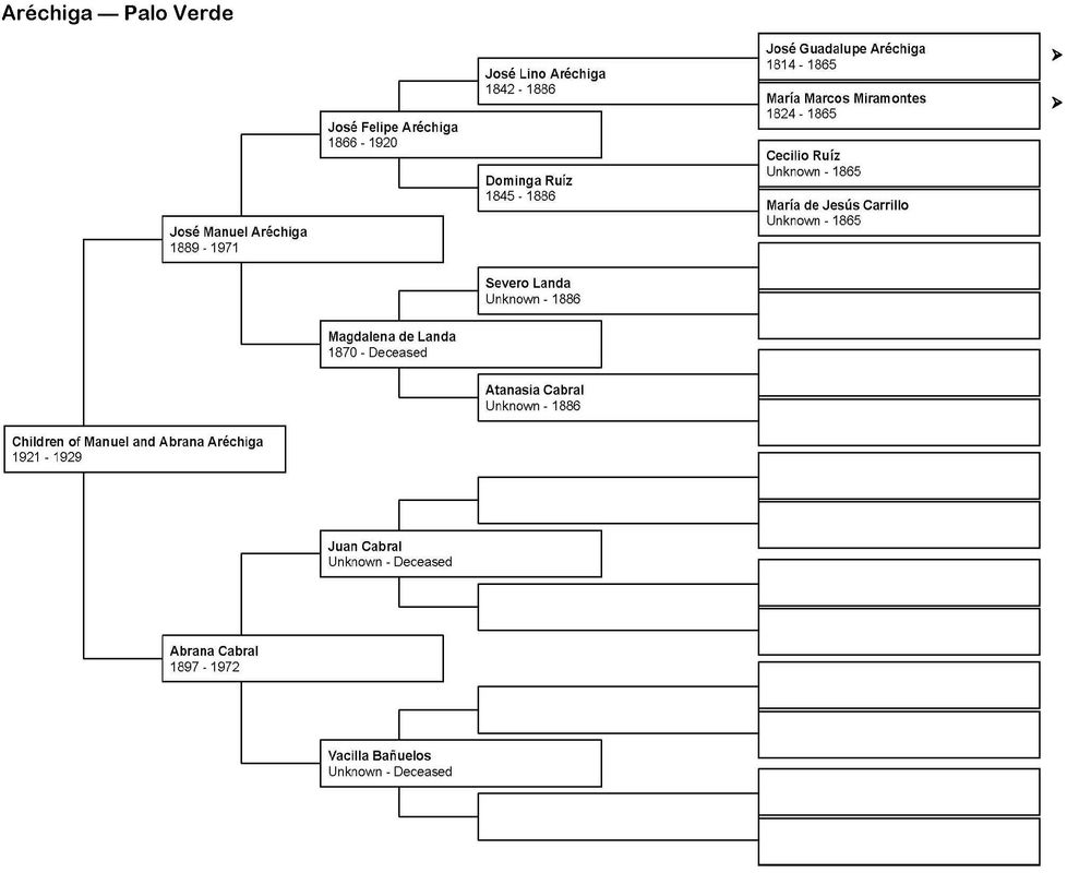 In a companion project, a directory has already been compiled that lists every resident of the neighborhoods. This directory was taken from the census data of 1920, 1930, and 1940, and from the voter registration lists of 1950. The directory lists nearly 6,000 names, and is indexed twice: first, alphabetically by name; and second, by street address. No, it's not whether the Dodgers win or lose their game today with the Chicago Cubs. I'm talking about the three neighborhoods of Palo Verde, La Loma, and Bishop, which were condemned and then destroyed to make room for an ill-fated public housing project called Elysian Park Heights. As everyone probably already knows, that ill-fated project was never built; and after nearly a decade of political manœvering, after ownership of the land reverted to the City of Los Angeles (which is a story in itself and involves Richard Nixon), it was sold for $1 to Walter O'Malley, who then built Dodger Stadium. Five thousand people, who were overwhelmingly Mexican and Mexican-American, were displaced. This is who lost today in history, irrespective of who wins today's baseball game. The Free Methodist Church, Palo Verde The Free Methodist Church was one of two churches that served the residents of Chavez Ravine; the other was El Santo Niño, which was a Catholic chapel. The Free Methodist Church was located at 1207 Effie Street, between Gabriel and Malvina Avenues in Palo Verde. On this date in 1948 — a mere two years before notice of the impending eviction was visited on the community — the Free Methodists took out a construction permit to add both a classroom and a women's restroom. Little did they know that they, along with their neighbors, were about to be evicted and their little church destroyed. The Vargas Family — Nearly 40 Years in Palo Verde September 11, 1913. On this date, José Gregorio Bargas (Vargas) took out a permit for construction of a 30' x 30', three-room house at 1763 Gabriel Avenue in Palo Verde. Gregorio, along with his wife, Rafaela Vanda, and four of their five children — José Ambrosio, 19; María Evarista, 12; José León, 11; and María Bonifacia, 5, were recent immigrants from México. A fifth child, Guillerma, just two months old, was born in Los Angeles. Whether the Vargas family already lived in Palo Verde when Guillerma was born is not known, but the family's appearance in Palo Verde makes them one of the first residents of that neighborhood, perhaps preceded only by the family of Francisco de León, owner of the City Center Grocery store at 1146 Effie Street, which was just down the block from the Vargas family home. October 18, 1940. José Gregorio's son, José Ambrocio, took out a permit to upgrade the house that his father had originally built in 1913. Ambrocio added a concrete foundation, installed new studs, rearranged the floor plan, re-wired the house, applied stucco to the exterior, and made general repairs. At the time of the 1920 census, the head of the Vargas household in the house on Gabriel Avenue was Gregorio and Rafaela's son, Ambrocio. Ambrocio Vargas and his wife, Tiburcia Gonzáles, were the parents by then of the first three of their nine children, including eight-month-old Porfio, who, in 1938, would marry a neighbor from Malvina Avenue, Aurora Aréchiga; volunteer for the Army during World War II; and be killed in action in the Pacific in 1944. Porfirio Vargas' body was never returned to the United States for burial. Porfirio Vargas' widow, Aurora, is best known as Aurora Vargas, who, along with her parents, Manuel and Abrana Aréchiga, refused to leave their home at 1771 Malvina Avenue at the time of the evictions, and who was evicted forcibly by Los Angeles County Sheriff's deputies on May 9. 1959, in an event that was captured on video. 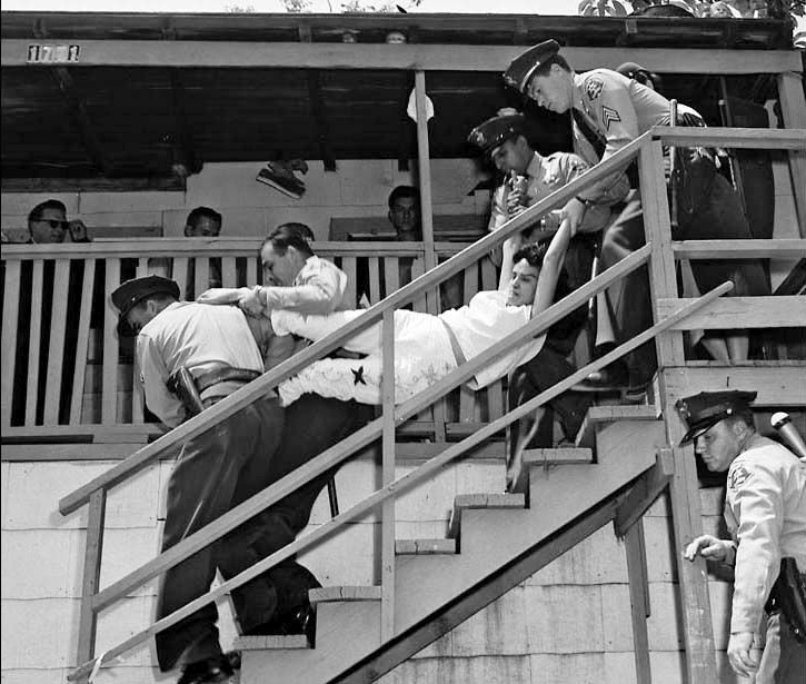 The Vargas family continued to live on Gabriel Avenue. They are documented in the 1920, 1930, and 1940 census returns. The original homesteaders of the family, Gregorio and Rafaela, died in 1937 and 1931, respectively. Ambrosio and Tiburcia Vargas eventually became the parents of nine children, and the family owned two houses on Gabriel Avenue, at 1763 and 1767. They continued to live in Palo Verde until they, too, were evicted during the 1950s. Let us not forget ... So, irrespective of whether the Dodgers win or lose tonight, one hopes that at least some of their fans will pause for a moment to remember that the proud and happy residents of Palo Verde, La Loma, and Bishop, in the end, did not win — rather, they lost everything, and what they lost was much, much more than just a baseball game. The facts that are reported here are the result of original historical and genealogical research by the author, whose birthday, coincidentally, is 33 years to the day after Gregorio Bargas took out his original construction permit in Palo Verde on September 11, 1913. October 18th, 2016This afternoon at 5:08 pm in Dodger Stadium, the Dodgers will host the Chicago Cubs in the third game of the National League Championship Series (NLCS). There will be games tomorrow and Thursday as well — all beginning at 5:08. Both automobile and stadium gates will open a full three hours before the game, at 2:08 pm. An excerpt from an email that was sent to (some) local residents from Erika Sanches, Coordinator, Community & Government Relations for the Dodger organization, set the stage for the impending invasion that residents dread but know is coming: Your Los Angeles Dodgers have advanced in the post season. As they have done for decades, the Dodgers organization will, for each of these games, perpetrate the fraud that will wreak havoc on the narrow streets and the residents of the communities surrounding the stadium in the form of bumper-to-bumper traffic, sometimes for hours, along with the concussions from fireworks that will frighten small children, the elderly and pets, rattle windows, and set off car alarms. Both of these outrages are clear violations of the Dodgers' Conditional Use Permit, but they don't care, because they know they can get away with it; and anyway, they have given the residents notice. What more could anyone ask for? Pyrotechnics should be expected during the lineup announcement and during the national anthem. This excerpt from an email of a resident to the Dodgers on August 19th, in reference to night 2 of the two-night Guns N' Roses concert in Dodger Stadium, clearly and legitimately articulates the issue: Are you ever going to respond to us? The noise emanating from the stadium is shaking up our peaceful community. My wife and I take care for our elderly mother with a heart issue and this is causing us a major stress. It is truly unbearable. It’s the loudest ever. We thought AC/DC and KISS were bad but now you’ve proven to us that it can get even worse. Needless to say, there was no response from the Dodgers; remember, they provide lip service but nothing else, because they simply don't care. Another resident sent this as part of an email on October 9th: Erika asks below if we have any questions [an email from Erika Sanchez was attached]. I have a question: how can you continue setting off fireworks, possibly twice in a single day, given that this is in clear violation of your Conditional Use Permit and despite numerous requests from your neighbors to reduce frequency and noise levels? And what was the Dodgers' predictable response? Nothing. Nada. Rien. لا شى. Ничего ... well, you get the picture. Meanwhile, on this day back in 1922 ... Telesforo Martínez applied for, and received, a construction permit for him to build a four-room home at 1808 Gabriel Avenue in Palo Verde. The home was occupied for nearly 30 years; but in 1951, the vacant home at 1808 Gabriel Avenue was demolished. The residence was vacant because Telesforo Martínez and all of the residents of 1808 Gabriel Avenue who came after him, had been evicted.
Today, 94 years after Telesforo Martínez built his home, Dodger fans will park their cars where the home of Telesforo Martínez once stood. Perhaps some of those cars will have sat in traffic for more than an hour on Solano Avenue in Solano Canyon or Scott Avenue in Echo Park. When the fireworks begin as the Dodger lineup is announced and the National Anthem is sung, the residents of the communities surrounding Dodger Stadium will, once again, suffer the indignity that has been perpetrated against them by an uncaring, powerful corporate entity, just as the residents of Palo Verde, La Loma, and Bishop suffered the indignities of the condemnation of their homes and the eviction of their persons that were perpetrated against them by an uncaring, powerful, civil entity so many years ago. Well, that’s a good place to take the poor people on Bunker Hill and put them with additional poor people in better-quality housing. — Robert Evans Alexander, chief architect of the Elysian Park Heights public housing project Racism can take many forms This story is but one example of how an inherent racism can be expressed, perhaps even unconsciously. Robert E. Alexander was interviewed in 1986 and 1987 by Marlene L. Laskey as a part of the Oral History program at the University of California, Los Angeles (UCLA). The transcripts of Alexander's oral history comprise some 769 typed, double-spaced pages in two volumes that were published in 1989. Much of the material refers to Alexander's career as an architect; but there is a portion that refers to the Elysian Park Heights public housing project that was originally proposed to be built in the area improperly known as 'Chavez Ravine' — the overwhelmingly Mexican and Mexican-American village in the Stone Quarry Hills that included the three neighborhoods of Palo Verde, La Loma, and Bishop. Robert Alexander's words speak for themselves, and they speak volumes. Laskey: "What was the site like? You might talk about what Chavez Ravine was in 1950. The following is Alexander's response in its entirety. Well, it was a ravine and a series of subsidiary canyons that came into the ravine. It was a high-class slum area. That is, if you were from Brooklyn or Manhattan you might not conceive of it as a slum, because it was all one-story shacks, but it was packing cases, people living in old chicken coops. It was squalor of the worst kind. But, you know, children growing up in that area must have had an enchanted life, in a way. I mean, they were surrounded by Elysian Park. Their ravine itself had not very many trees in it, but it was country living, as if it was a little place in Mexico. It wasn’t all that bad from the standpoint of living conditions. From the standpoint of sanitation and so on, not too hot. The housing was not the greatest. There was no toilet or bathtub in every unit, you know. The housing criteria devised by the census bureau to define whether the housing was safe and sanitary, as they say, don’t tell the whole story. In a way it was an idyllic situation, in spite of its squalor. 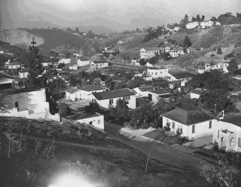 Before we deconstruct Alexander's confused and convoluted description of the village, keep in mind the image above, which dates from 1950, shortly before the evictions began. The photograph was taken from above the Police Academy, looking South toward La Loma. ... it was a ravine and a series of subsidiary canyons that came into the ravine. Like so many both before and after him, Alexander belies any real understanding of the geography of the area. There were five ravines in the Stone Quarry Hills: Chavez, Sulphur, Cemetery, Solano, and Reservoir. Palo Verde was in Sulphur Ravine and on the loma between Sulphur and Cemetery Ravines; Bishop was situated entirely in Cemetery Ravine; and La Loma took its name from the loma on which it sat, between Cemetery and Solano Ravines and adjacent to the contiguous, neighboring community of Solano. None of the ravines in the Stone Quarry Hills could properly be called a 'canyon', despite the fact that they were sometimes referred to in that way. But Alexander was not alone in his lack of understanding of the geography; Frank Wilkinson, Harold Holtzendorf — even Don Normark and later, Ry Cooder — were not entirely clear on the geography. It was a high-class slum area. That is, if you were from Brooklyn or Manhattan you might not conceive of it as a slum, because it was all one-story shacks, but it was packing cases, people living in old chicken coops. It was squalor of the worst kind. Here, Alexander is comparing the village in Chavez Ravine with the high-density tenements found in some East Coast cities like New York, Boston, and even Chicago. But this is where Alexander stumbles once again. He describes the housing as "... one-story shacks ..." that were constructed of "... packing cases, people living in old chicken coops ...". But take another look at the photograph, above. Of the many homes in the photograph, one sees neither packing crates nor chicken coops; nor, for that matter, are all the homes single-story — there are at least a half-dozen multi-story homes in this photograph alone. Most of the homes appear to be made of stucco on the outside, with porches and windows. There are paved streets, gardens, and trees. Alexander then goes on to describe his opinion of life in the village. But, you know, children growing up in that area must have had an enchanted life, in a way. I mean, they were surrounded by Elysian Park. Their ravine itself had not very many trees in it, but it was country living, as if it was a little place in Mexico. It wasn’t all that bad from the standpoint of living conditions. So what does Alexander think of life in the village? He doesn't seem to know what he thinks. Was it a slum? And what, exactly, is a slum? Lacking any legal or statutory definition, the term slum then is defined only in the eye of the beholder and becomes subject to the prejudices of the person who uses the term. But it can — and is, and was then — wielded like a cudgel and applied to any area that the Anglo city planners wished to destroy. The racist overtones of that process fairly scream at us today. Alexander's final statement is a combination not only of his own prejudice, but also of his confusion; he doesn't really know what he thinks ... nor do we have any idea from his description. In a way it was an idyllic situation, in spite of its squalor. "... an idyllic situation, in spite of its squalor." If life in the village constituted an idyllic situation, then why was is necessary to destroy it? Was it racism? White privilege? The power of a dominant culture to make decisions for a disenfranchised, minority culture? We do not know; but Alexander's confused, convoluted description of life in the ravines has value, if only to serve as a bad example. Latinos, Beísbol, and Chavez Ravine ... Latinos and baseball ... When I think of Latinos and baseball, my first thought is not of the Los Angeles Dodgers and Dodger Stadium; rather images come to me from my imagination — images of my father and his father, playing baseball in Elysian Park, early in the 20th Century. You see, they both grew up in Solano (my grandfather was born there in 1895), and Elysian Park was their playground. I am reminded of the Mexican and Mexican-American village in the Stone Quarry Hills that was destroyed, with its three neighborhoods of Palo Verde, La Loma, and Bishop. Finally, of course, I am reminded of the Dodgers and Dodger Stadium. That mental image of my father and grandfather in Elysian Park is suggested by the following photograph, which has been in my family for more than a century. 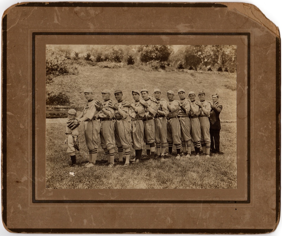 This is a group photograph of a business-sponsored, semi-pro baseball team in Los Angeles that was taken in Elysian Park in 1912. This particular team was sponsored by the Tufts-Lyon Arms Company. The team is Tufts-Lyon No. 2, and the fourth person from the left is the team's shortstop, 17-year-old Teodoro Manuel Bouett, my grandfather — the only Latino on the team, who was encouraged to play baseball by his maternal uncle, Alfredo Solano, who was a founding member of the Los Angeles Athletic Club and who played for the Athletic' Club's baseball team during the 1880s — and he, too, was the only Latino on the team. Alfredo Solano, my great-granduncle, is standing in the top row, left-hand side. He was about 27 years old when this photograph was taken around 1884. 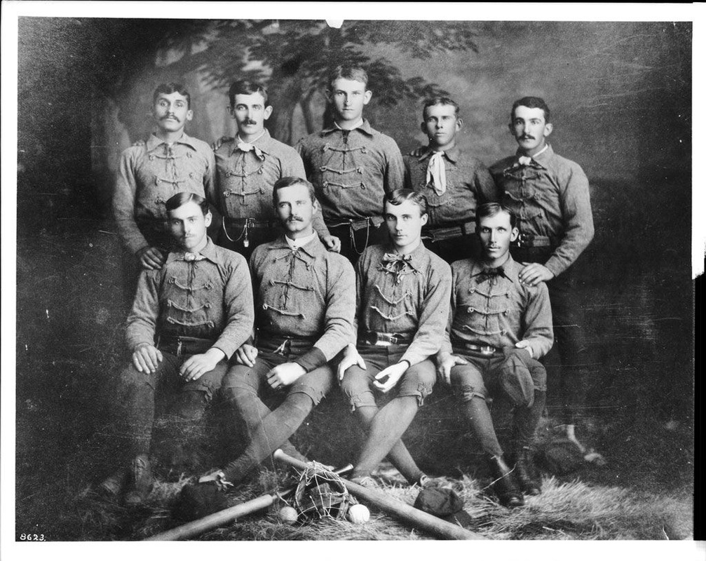 My primary interest in this area, though, is the history of the village that was destroyed during the 1950s — that is, the neighborhoods of Palo Verde, La Loma, and Bishop. My grandfather's grandfather, Francisco Solano, bought 87 acres of land in the Stone Quarry Hills in 1866; that land became much of those three Mexican and Mexican-American neighborhoods, plus the community of Solano, which is celebrating its sesquicentennial — its 150th anniversary — this year. Those three neighborhoods — Palo Verde, La Loma, and Bishop — have often been called 'Chavez Ravine', presumably a reference to the urban legend that the land once belonged to Julián Cháves, a legend that is categorically untrue. In fact, 122½ acres of the land in the Stone Quarry Hills belonged to members of my family — the Solanos — and became, in addition to Solano, the neighborhoods of La Loma, Bishop, and about half of Palo Verde Northeast of Effie Street. That land remained in my family continuously from 1866 until 1903, when it was sold to developers. The first houses in the village appeared in 1909 in La Loma, 1912 in Bishop, and 1913 in Palo Verde. So why is the area credited with a mythical connection to Julián Cháves? So why is the area credited with a mythical connection to Julián Chávez? I suspect that the origin of that urban legend lies with the 82 acres that Cháves did own in Elysian Valley, or Frogtown, that lies on the flat land by the Los Angeles River to the Northeast of the Stone Quarry Hills. Cháves acquired that land in 1847 during the Mexican Period in Los Angeles from Estefan Quintano, not the ayuntamiento, and in 1856, it was surveyed at Cháves' request by George Hansen, the Los Angeles County Surveyor. To the Northwest of Julián Cháves' 82 acres in Frogtown in 1856 is a 33-acre parcel that belonged to his brother, Mariano; and adjacent to Mariano's land is a 150-acre parcel that belonged to Juan Bouet, my great-great grandfather. There is a place named Chavez Ravine. It is the first ravine in the Northwest of the Stone Quarry Hills; but it is nowhere near those three neighborhoods. The five ravines in the Stone Quarry Hills are Chavez, Sulphur, Cemetery, Solano, and Reservoir. Bishop's Road runs up Cemetery Ravine, where all of the neighborhood of Bishop was situated. Dodger Stadium is located primarily in Cemetery Ravine, Sulphur Ravine, and against Mt. Lookout. Neither Julián Cháves nor his brother, Mariano, ever owned land in the actual Chavez Ravine; rather, a burro trail up Chavez Ravine crested the summit of the Stone Quarry Hills, then descended through a narrow defile and debouched onto the tract of Juan Bouet, and which provided access to Elysian Valley and the land to the North, like Rancho los Feliz and the San Fernando Valley. So why the name Chavez Ravine for an area that Julián Cháves literally had nothing to do with? The answer is probably illuminated in part by a conversation sometime around 1947 between Harold L. Holtzendorf, the Executive Director of the Housing Authority of the City of Los Angeles (or HACLA for short), and Robert E. Alexander, whom Holtzendorf recruited to be the chief architect of the Elysian Park Heights public housing project. The apple of my eye is the Chavez Ravine project. According to Alexander's oral history, Holtzendorf told him, "The apple of my eye is the Chavez Ravine project." Just how, and when, Harold Holtzendorf coined the term 'Chavez Ravine' for the area is unknown; but Frank Wilkinson, Special Assistant to Holtzendorf at HACLA, perpetuated the term in his 1950 notification to the residents of the neighborhoods about the Elysian Park Heights project, although Wilkinson's notification was addressed "To the residents of the Palo Verde and Chavez Ravine Areas". The area that was ultimately condemned did, in fact, include a portion of the actual Chavez Ravine. But from 1950 forward, the area was always referred to as Chavez Ravine by the political power structure in Los Angeles, and especially in the hundreds of articles in the Los Angeles Times about the public housing project. Interestingly, no survivor of the evictions that took place in Palo Verde, La Loma, and Bishop, nor any of the next generation, for that matter, has ever claimed that they referred to where they lived as Chavez Ravine. Now, don't get me wrong: I'm not a crusader, and I suspect that there is no way anyone is ever going to drop the term 'Chavez Ravine' from their vocabulary to refer to the three destroyed neighborhoods of Palo Verde, La Loma, and Bishop; but as an historian, it is important to me to understand the dynamics that were in play that resulted in something so wildly inappropriate as the term 'Chavez Ravine' to refer to the neighborhoods that were destroyed during the 1950s, ultimately to make way for the construction of Dodger Stadium. WARNING! This blog contains some statistics, data tables, charts, and graphs, along with their analyses. So if all you want is a short answer, then here it is:
|
About the AuthorLawrence
Bouett is a retired research scientist and registered professional
engineer who now conducts historical and genealogical research
full-time. A ninth-generation Californian, he is particularly interested in the displacement of the nearly 1,100 families that lived in the Chavez Ravine communities of la Loma, Palo Verde, and Bishop to make way, ultimately, for the construction of Dodger Stadium. His ancestors arrived in California with Portolá in 1769 and came to Los Angeles with the founders on September 4, 1781. 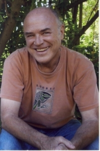
CategoriesArchives
January 2018
|


 RSS Feed