The 5-generation Genealogy Project
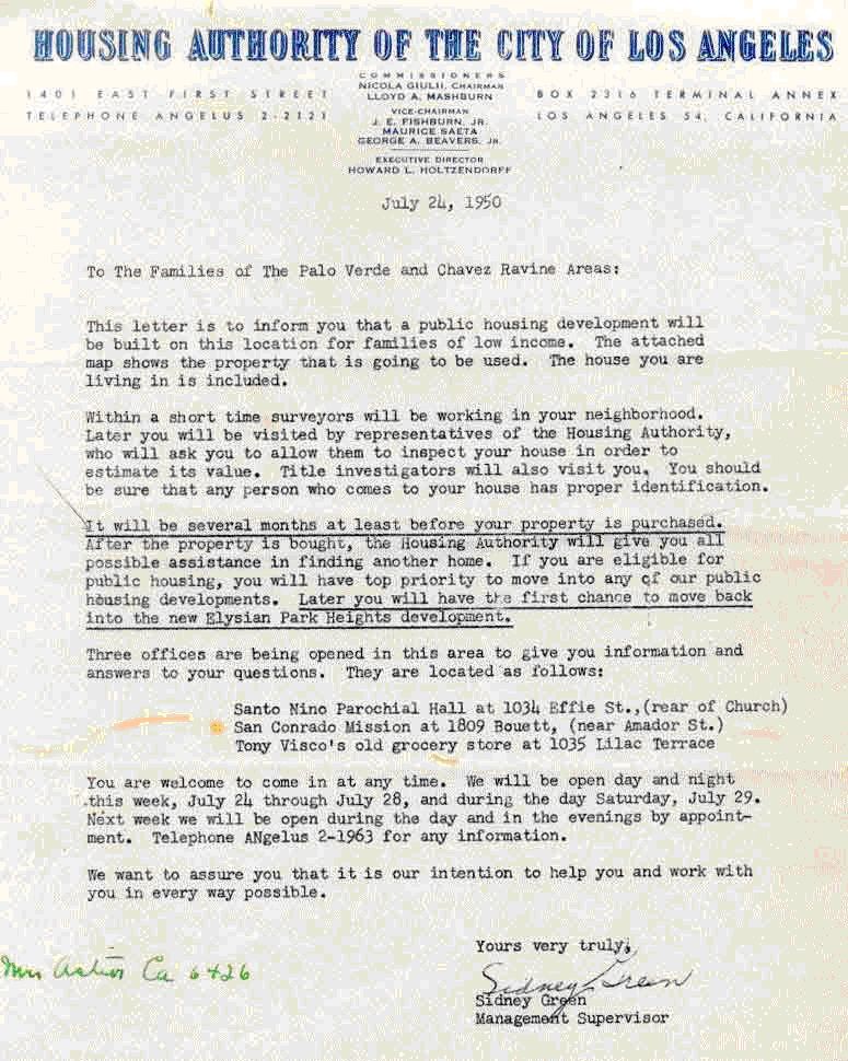
The name 'Chavez Ravine' is a misnomer here was in Los Angeles by 1950 a thriving, vibrant, predominantly Mexican and Mexican-American village of more than 5,000 people living in the Stone Quarry Hills about a mile to the Northeast of downtown Los Angeles, a village that comprised the three neighborhoods of Palo Verde, La Loma, and Bishop. It is well-known that the village was condemned and destroyed during the following decade so that a Federal public housing project known as Elysian Park Heights could be built. Elysian Park Heights, for a variety of reasons, was never built, and once ownership of the land had reverted to the City of Los Angeles by mid-decade, it was subsequently sold to Walter O’Malley, who brought his Brooklyn Dodgers baseball team to Los Angeles in 1958. O’Malley used a portion of the land he received from the City to build Dodger Stadium, which opened on April 10th, 1962 as the home of the now-Los Angeles Dodgers. The village that once existed in the Stone Quarry Hills has been referred to for decades as ‘Chavez Ravine’; that term is firmly a part of the lexicon of the area, and it is used today to refer, not only to the village that was destroyed, but also to Dodger Stadium itself. However, use of the term ‘Chavez Ravine’ to describe the Mexican and Mexican-American village in the Stone Quarry Hills that was made up of the three neighborhoods of Palo Verde, La Loma, and Bishop is a misnomer; in fact, its use as a name for the village is historically inaccurate in every way and it improperly describes the area. Urban legends abound, and in this case, the name ‘Chavez Ravine’ actually comes from the nearby geographical feature of the same name. The Stone Quarry Hills is the elevation on which sits Los Angeles’ Elysian Park. The land was uplifted millions of years ago in geologic time, and as the land rose, rivers cut the land, producing five ravines that are known in modern times, from Northwest to Southeast, as Chavez Ravine, Sulphur Ravine, Cemetery Ravine, Solano Ravine, and Reservoir Ravine. Chavez Ravine was named for Julián and Mariano Cháves, brothers from New Mexico Territory who were active in Los Angeles during the mid-19th Century. The ravine was so-named because there was a burro trail that led up the ravine, crested the summit of the Stone Quarry Hills, descended through a narrow defile, and debouched onto the flat land to the Northeast of the hills by the Los Angeles River. This land was owned, in 1856, by Julián Cháves, his brother, Mariano, and Juan Bouet. Originally referred to as Frogtown, it is known today as Elysian Valley. Complicating the urban legend, however, is the fact that neither Julián Cháves nor his brother, Mariano, had any connection whatsoever to the three neighborhoods of Palo Verde, La Loma, and Bishop, nor did they, at any time, own any of the land in the village that eventually was destroyed or to the land where Dodger Stadium sits today. Chavez Ravine, the westernmost of the five ravines in the Stone Quarry Hills, has no direct geographic connection to any of the neighborhoods.[1] Of the three neighborhoods that comprised the village, La Loma existed entirely on the loma between Solano and Cemetery Ravines. La Loma got its name because of the loma on which most of the neighborhood was built, and it was contiguous with the upper portion of the present-day community of Solano Canyon on its southeast edge and with Bishop on its northwest edge. There are first-generation survivors of the evictions of the 1950s who describe walking down the loma from La Loma to visit friends on Amador Street or Solano Avenue ‘in Solano’, or who talk about how, as children, they left La Loma to walk ‘through Solano’ to attend school at the Solano Avenue School.[2] 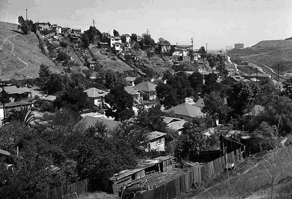 Bishop, with only 80 houses along the two blocks of Bishops Road between Effie Street and Park Row in 1940 — the 1700 and 1800 blocks — was the smallest of the three neighborhoods, both in area and in population, and its only street was Bishops Road. Sometimes improperly referred to as its being located in Bishops Canyon, a geographical feature that never existed, Bishop was actually located entirely within Cemetery Ravine. Although the sides of several of the ravines in the Stone Quarry Hills, including Chavez Ravine, were steep, none could properly be described as a canyon. As the land rose again to the Northwest from Bishops Road onto the loma that was between Cemetery and Sulphur Ravines, the houses that were built there became part of the Palo Verde neighborhood, beginning with the houses along Davis Street. This largest of the three neighborhoods continued for six blocks along Effie Street, all the way from Davis Street to Boylston Street; it existed on both sides of Effie Street. Where did the name 'Chavez Ravine' come from? There has been extensive, legitimate use of the term ‘Chavez Ravine’ over time. Maps as early as 1856 labeled the westernmost of the five ravines in the Stone Quarry Hills ‘Chavez Ravine’. This was due to the fact that the aforementioned burro trail that led up that particular ravine provided access to the 82-acre tract that was acquired in 1847 by Julián Cháves. Cháves’ property was located on the flat land by the Los Angeles river that was later called Frogtown and which is known today as Elysian Valley; in 1856, Cháves’ land was adjacent to the 33-acre parcel of his brother Mariano, which in turn was adjacent to the approximately-150-acre parcel of Juan Bouet. Equally as important as the access that the trail up Chavez Ravine provided to the Cháves and Bouet properties on the flat land near the Los Angeles River in Frogtown was the fact that the same trail also provided access to the San Fernando Valley and to the land to the North of Los Angeles, such as Rancho Los Féliz and Misión San Fernando Rey de España. The term ‘Chavez Ravine’ had also been used for decades prior to the 1950s to refer to locations and events in the actual Chavez Ravine, such as the locations of the several Pest Houses of the mid- to late 19th-Century, the Barlow Respiratory Hospital, which was built in 1903 along Chavez Ravine Road, several brickyards, and the Naval Reserve Armory of the 1940s, which, like the Barlow Hospital, was also located along Chavez Ravine Road. All of these places were in Chavez Ravine itself or along Chavez Ravine Road. The three destroyed neighborhoods of Palo Verde, La Loma, and Bishop were nowhere near the geographical feature called Chavez Ravine. Neither Julián Cháves nor his brother, Mariano, ever owned land in Chavez Ravine itself or had anything to do with the land that became the three neighborhoods that were eventually destroyed. Dodger Stadium, which has also referred to as Chavez Ravine by some, was built primarily in Sulphur Ravine, on the loma between Sulphur and Cemetery Ravines, and against Mt. Lookout. So how, then, did that entire area of more than 340 acres that was condemned during the 1950s come to be called ‘Chavez Ravine’, since the term is so clearly used inappropriately today to describe anything that was ever built there? The answer can probably be attributed to Frank Wilkinson, Special Assistant to the Executive Director of the Housing Authority of the City of Los Angeles (HACLA) under HACLA Executive Director Harold L. Holtzendorf, in 1950. As Special Assistant to the Executive Director, Frank Wilkinson was powerful, his authority was great, his responsibilities were as broad as he and Executive Director Holtzendorf cared to make them, and Wilkinson was instrumental — although not the primary driver — in the process that led to the eviction of the residents of the so-called ‘Chavez Ravine’ communities and the ultimate destruction of their homes. The first documented use of the term ‘Chavez Ravine’ to refer to that part of Los Angeles that included the neighborhoods of Palo Verde, La Loma, and Bishop occurred on 24 July 1950 in the form of a certificate, prepared by Wilkinson himself and issued under the signature of Sidney Green, Management Supervisor of the Housing Authority (HACLA). By Wilkinson’s own admission, the certificate, which he says he wrote, was distributed personally by him to every home in all three of the neighborhoods. The assertion that it was Wilkinson who wrote and distributed the certificates is documented in the film, Chávez Ravine — A Los Angeles Story, in which Wilkinson, who was interviewed on-camera for the film, says that it was he who personally wrote the July 1950 certificate and delivered it to every household. That certificate was effectively a death warrant for the way of life in the Mexican and Mexican-American village that contained more than 1,100 homes and 5,000 people, although that outcome had very likely already been determined by HACLA.
 Just how, why, and under what circumstances Frank Wilkinson used the term ‘Chavez Ravine’ to describe a portion of the area that was ultimately condemned and destroyed, is not known. The term was also used by Wilkinson’s boss at HACLA, Harold Holtzendorf, although Holtzendorf appeared to use the term to refer to the entire area, while Wilkinson also used the term ‘Palo Verde’ in the same context. Once used, however, the term seemed to stick, and it was used widely and repeated often, especially by the Los Angeles Times in its hundreds of reports of the dozens of public meetings that were held by the Housing Authority about the public housing project that was known as the Elysian Park Heights public housing development. Once the minority Mexican and Mexican-American residents of the communities of Palo Verde, La Loma, and Bishop were evicted from their homes, their properties condemned, and their homes destroyed; once the public housing project known as Elysian Park Heights was abandoned, largely due to public, lobbying, and political pressures; once ownership of the land had reverted to the City of Los Angeles with an assist in Congress from California United States Senators Richard M. Nixon and William F. Knowland; and once Walter O’Malley had brought his Brooklyn Dodgers baseball organization to Los Angeles and built a stadium on the land that had once been the home to more than 5,000 people, most of whom were Mexicans and Mexican-Americans; at that point, Vin Scully and Jerry Doggett, the ‘voices of the Los Angeles Dodgers’, began to use the term to describe the baseball stadium itself, which is a misnomer if ever there was one. One can perhaps understand, however, their reluctance to refer to the stadium as ‘Sulphur Ravine’. By that point, then, the term ‘Chavez Ravine’ to refer to the area that was more properly referred to as ‘Palo Verde’ had become so firmly implanted in the minds of most Angelinos that it would have been virtually impossible to convince anyone that the more than 5,000 residents of the destroyed neighborhoods of Palo Verde, La Loma, and Bishop never themselves referred to the location of their homes as ‘Chavez Ravine’— not that anyone tried, of course. There are many of those who were evicted who are alive today, although their number is dwindling over time, and not one of them has ever come forward to claim that they called the area where their homes were once located by the name ‘Chavez Ravine’, even though many of them may use the term casually today. Some of the eviction survivors are friends and family members of the Santillán family; they have formed a loose but loyal organization of evictees who have met annually during the Summer for nearly four decades and who call themselves Los Desterrados. Others have formed additional informal family or neighborhood groups. Frank Wilkinson ultimately expressed his regret at that he had accomplished.
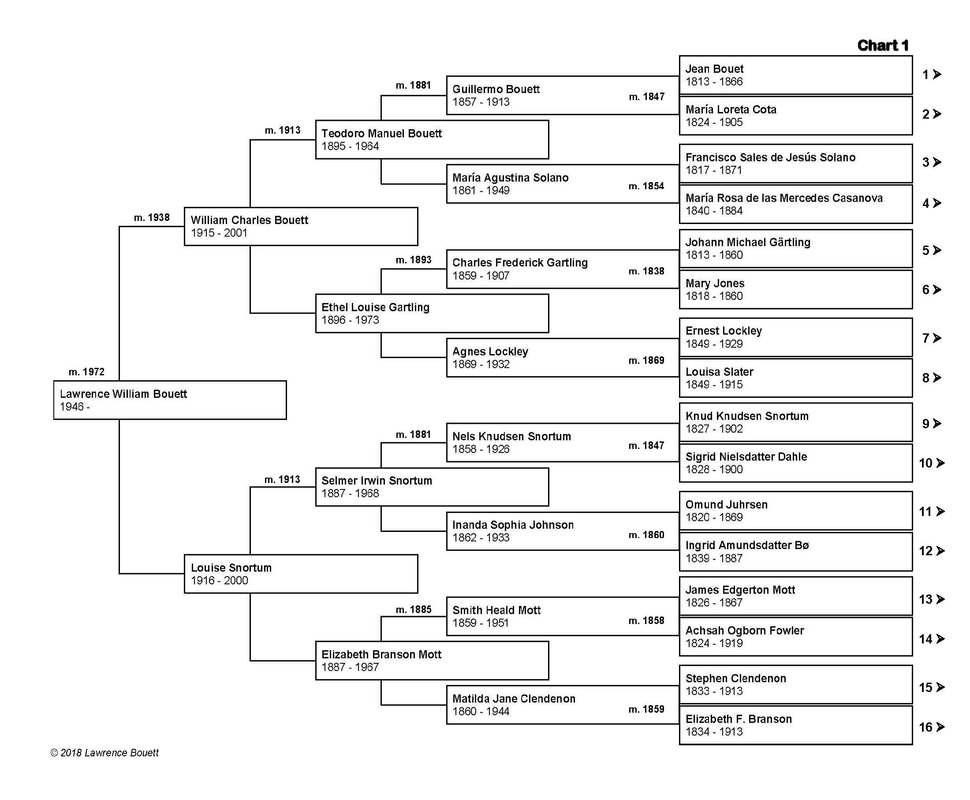
While the destruction of more than 1,100 homes in the three neighborhoods and the eviction and scattering of its residents from their homes may represent the tragedy of Frank Wilkinson’s life (which seems doubtful, given subsequent events), it is also fair to say that those same events represent the singular tragedy of the more than 5,000, primarily Mexican and Mexican-American lives as well. Some of the evictees bear the emotional scars of the events of the early 1950s to this day, more than six decades later. Wilkinson’s comment is gratuitous; he professes not to know how many people were uprooted and evicted from the neighborhoods; he says, “I was responsible for uprooting — I don’t know — how many hundreds of people ...”. By suggesting that it was ‘hundreds of people’ without his acknowledging that the number was actually more than 5,000 is staggering. Finally, when he says that those ‘hundreds of people’ lived in ‘their own little valley’, when in fact there were people living in several ravines and on several lomas also leads to the inevitable conclusion that Frank Wilkinson really did not know the village or understand its people at all. It is likely that HACLA’s Harold Holtzendorf and Frank Wilkinson actually had no clear idea how many people lived in the neighborhoods of the Stone Quarry Hills; one suspects, however, that they were fully-aware that the residents were overwhelmingly Mexican, and one wonders whether, and to what extent, that fact played a role in subsequent events. Notes: [1] At its closest point, Chavez Ravine is more than 1000 feet distant from any portion of the village, and on average, it is more than ½-mile distant. [2] The Solano Avenue School referred to here is actually the second Solano Avenue School that was built. The first school was in existence at least by the early 20th Century. [3] Chavez Ravine — A Los Angeles Story. Los Angeles: Tiny Projects, 2003. Video. Running time: 23:41. Frank Wilkinson’s comment occurs at minute 8:05 of the video. There is an ongoing project underway to compile the genealogies of as many residents of the three neighborhoods of Palo Verde, Bishop, and La Loma as possible. This project will take a very long time, but in the end, it will show how some of the residents were related to each other. The following chart is an example of the type of document that will be produced by the genealogy project: 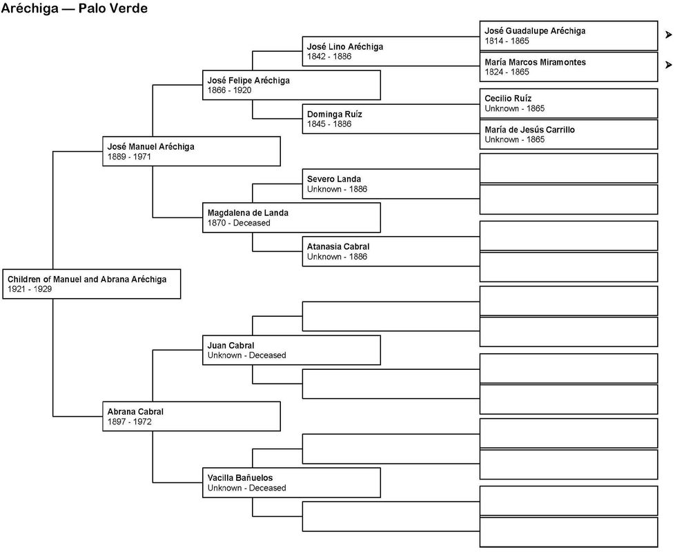 In a companion project, a directory has already been compiled that lists every resident of the neighborhoods. This directory was taken from the census data of 1920, 1930, and 1940, and from the voter registration lists of 1950. The directory lists nearly 6,000 names, and is indexed twice: first, alphabetically by name; and second, by street address. |
About the AuthorLawrence
Bouett is a retired research scientist and registered professional
engineer who now conducts historical and genealogical research
full-time. A ninth-generation Californian, he is particularly interested in the displacement of the nearly 1,100 families that lived in the Chavez Ravine communities of la Loma, Palo Verde, and Bishop to make way, ultimately, for the construction of Dodger Stadium. His ancestors arrived in California with Portolá in 1769 and came to Los Angeles with the founders on September 4, 1781. 
CategoriesArchives
January 2018
|
 RSS Feed